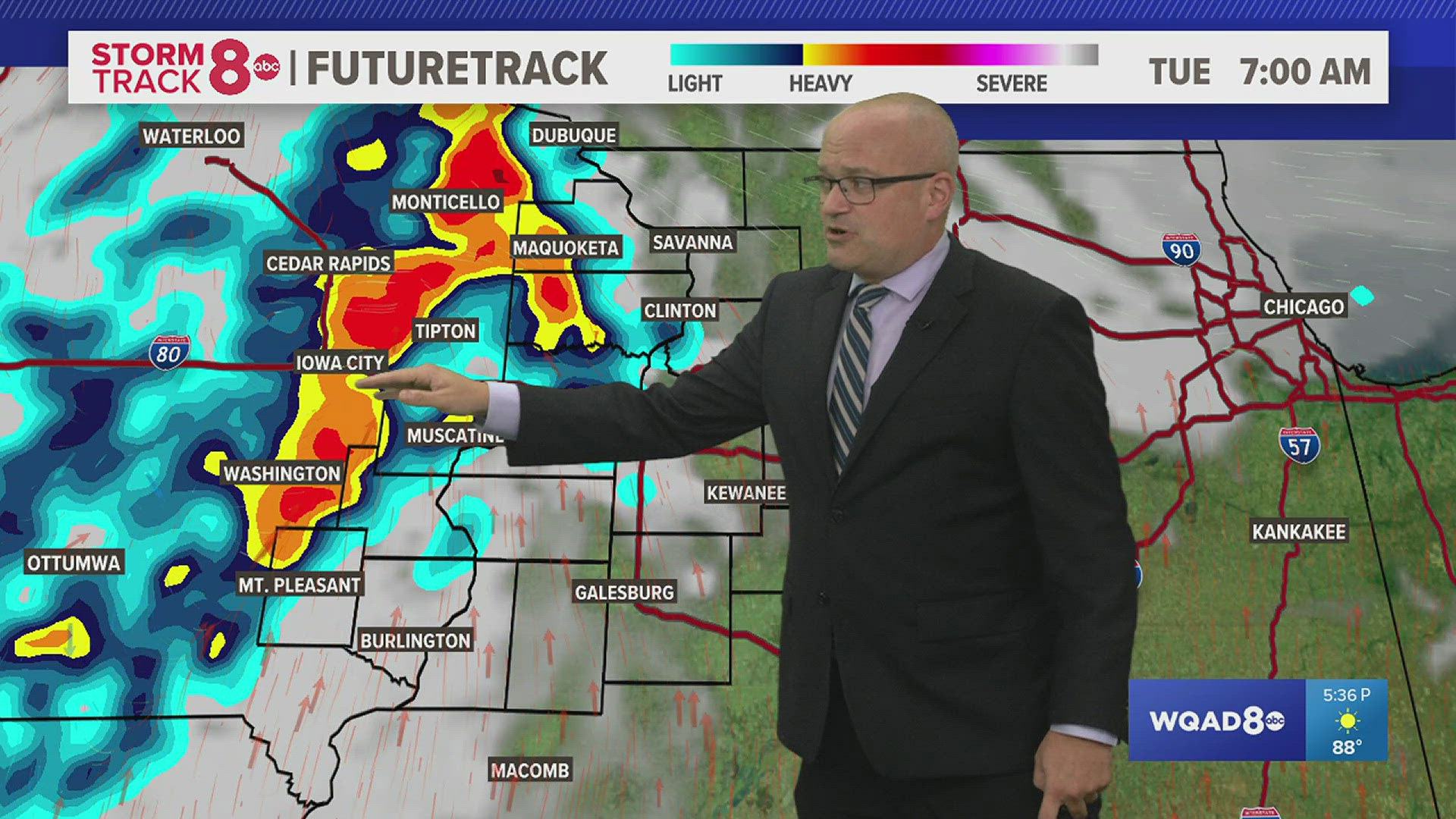
MOLINE, Ill. — Before yesterday’s snow event, meteorologists would show you different models during their forecast about possible outcomes. Models are tools that we use aid us in forecasting, but we don't solely rely on them. In this article you will learn about weather models and the different types that we use to aid us in forecasting.
What are weather models?
Weather models are computer programs that help predict the weather. These models use a set of mathematical equations based in physics that characterize how air, heat and moisture move through the atmosphere. Sensors are used to to collect weather observations such as temperature, wind and pressure to put them these equations. This is known as data assimilation.
The atmosphere is divided into each 3-D grid and each grid point is given the assimilated data. The first grid points are where the assimilated data is put is known as the initial conditions. As time moves forward, the mathematical equations are recalculated and reapplied for the new time. This continues based on how far into the future the model is programmed to go, which can last from several hours to weeks in advance.
No weather model is perfect. Some issues with weather models are that we cannot know the weather at every point on Earth. Therefore, we must often spread our grid points by hundred of miles causing for gaps in weather information. Sensors that we use to collect weather parameters can experience an error or breakdown which can then give us the wrong outcome. The model can predict to warm or cold.
Due to these reasons there are many different types of models. There are long and short-term models, regional/mesoscale, or global. There are models that are used for a specific weather event or parameter. Different mathematical equations are used for different types of models based on what they are meant to show. A meteorologist must take all of this into account when we are forecasting.
Types of weather models
There are global models and regional models. Global models cover the world and have not as clear resolution. Mesoscale/Regional models have higher resolution. Mesoscale are weather events that happen at a smaller scale such as thunderstorms, squall lines, or land-sea breezes. Each model has their pros and cons.
Types of global models are the Global Forecasting System (GFS) and European Center for Midrange Weather Forecasting (ECMWF) meteorologists usually just call it the Euro model.
The GFS is an American model and goes out 384 hours. A concern of the GFS is that it can overhype or overestimate systems in the long range, systems that are days away or weeks away since it can predict up to 16 days out, to be stronger than what they are.
Most meteorologists, when looking at weather in advance, proceed cautious when looking at weather so far out so they don't to get their hopes up. Overall, it is a good model and is widely used by meteorologists.
The Euro (EMWF) goes as far as 240 hours out, the equivalent of 10 days. A concern with this model is that it has cutoff lows in the southwestern US, overamplifies upper level systems, and has biases in the upper troposphere. The last two concerns deal with upper part of the atmosphere which can then affect the weather at the surface.
Global models are used a lot for long-term forecasting, trying to pick out future trends, and upcoming patterns. They can used be for short-term forecasting, but the coarse resolution they would provide can cause some issues at times.
Regional and Mesoscale Models include the North American Model (NAM), Rapid Refresh Model (RAP), and the Weather Research and Forecasting Model (WRF).
The NAM goes out 84 hours which is three and half days. Some concerns are between the 72 to 84 hours range where it goes back and forth on what to expect. The video above, shows my 10 p.m. Sunday forecast before the snow got here late Tuesday night and early Wednesday morning. I briefly talk about the change the in the NAM from when I did the weather during the 5 p.m. newscast, which falls in the range of flip-flopping on what is going to happen. Other concerns are that it is not always as accurate with near surface parameters such as temperatures or precipitation.
The RAP goes out 18 hours, but concerns of its low accuracy in mountainous areas. The WRF goes out 36 hours, but it can predict temperatures too low in the Southeast and predict too much precipitation.
Regional/Mesoscale Models have higher resolutions and use observations, so they are great to use for short-term forecasting. They can provide more detail about a situation once it is closer than a long-range model which help meteorologist better determine what will happen as the weather event gets closer.
Models are great tools to help aid meteorologists in forecasting, but we do not solely rely them. We use them in combination with what we learn in school about the atmosphere and how it works.
There are times where we decided to go against the models because we know what we are seeing doesn’t align with what we know.