MOLINE, Ill. —
What is La Niña?
La Niña is a climate pattern that affects the weather. The National Oceanic and Atmospheric Agency (NOAA) describes La Niña, which means "little girl" in Spanish, as an event where trade winds are stronger than usual pushing more warm water towards Asia.
This results in an increase in upwelling (rising sea water) which brings cold nutrient waters to the surface. The ocean is warmest at the surface due to the sun rays which can only go down about 1000 meters (approximately 328-feet) deep.
After that, the ocean becomes dark and cold, and the further you go down the colder the temperatures. As strong trade winds push warm waters west, a void at the top causes cold waters to rise in order to fill the space (upwelling).
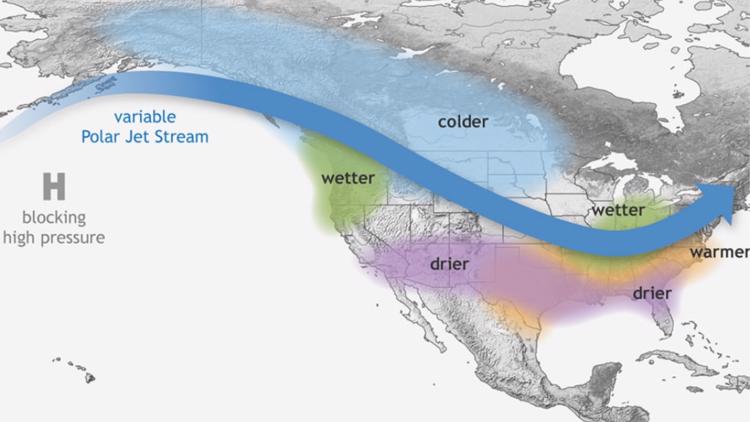
The atmosphere and ocean are connected, so as the cold water rises it will cause the jet stream to be pushed further north.
The jet stream is affected by ocean temperatures due to evaporation of warm water, wherever the warmest water is at, that is where the greatest evaporation occurs which is where you will find the jet stream.
During a La Niña winter, since all warm water is pushed west and cold water comes up, the jet streams travels upward where the warmest water are now located since that is where the greatest evaporation is occurring.

The northward movement of the jet stream affects the weather we experience.
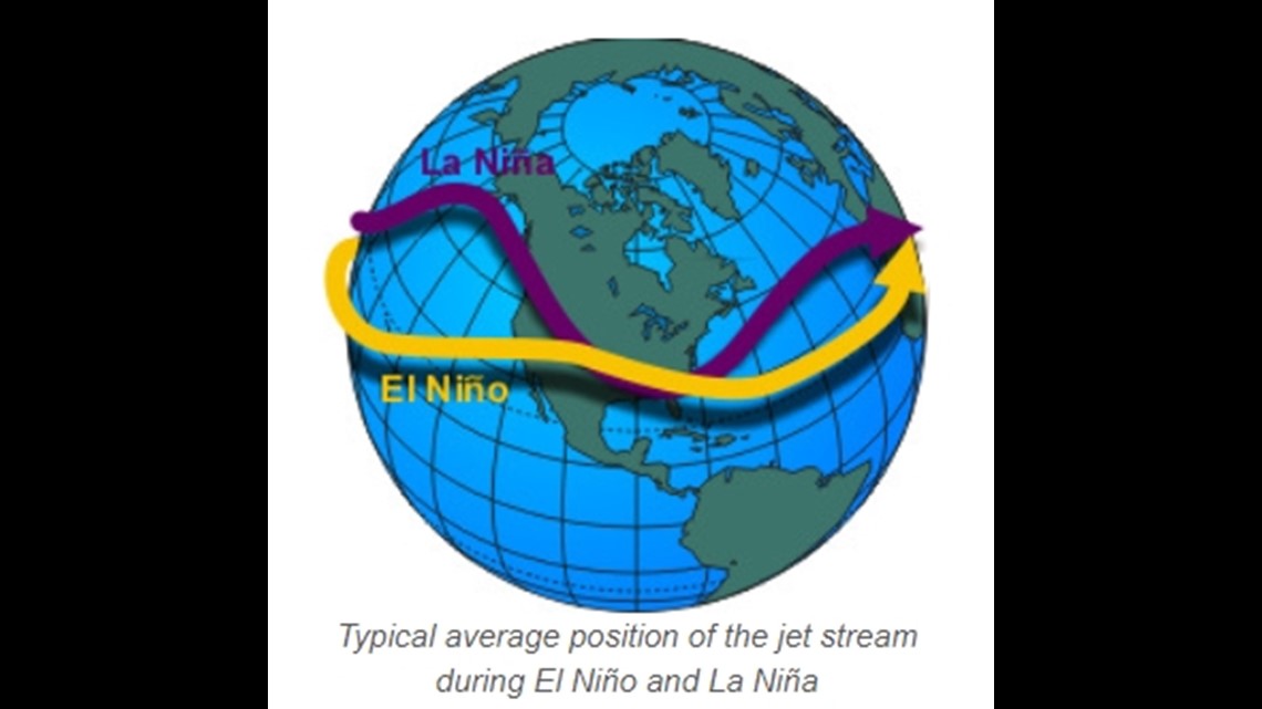
Jet streams alter affects by moving weather systems (high or low pressure), across the U.S. affecting temperature and precipitation. The location of the weather system in relation to the jet stream can affect our weather as well. If a system is too far away from a jet stream it can stall causing heat waves (high-pressure system) or flooding (low-pressure system). If close, then it will continue to move east, not stalling.
A northward movement of the jet stream during a La Niña causes drought conditions in the southern U.S. and heavy rainfall and flooding in the Pacific Northwest. During a La Niña winter temperatures are warmer in the south and colder in the north.
Here in the Quad Cities, we are just on the edge of wetter conditions which means slightly more snow in the winter. We will be transitioning into an El Niño this spring heading into summer, but if La Niña were to stick around, we will have a more severe hurricane season.


La Niña Winter 2021-2022
When people hear of La Niña in the Quad Cities, they think they are going to get more snow than average for winter.
So far, we've had a mild winter, but are we experiencing the effects of La Niña or not?
We still have the remainder of January and February to go.
On Oct. 21, NOAA published their winter outlook with the return of La Niña from December 2021 to February 2022.
The findings are shown in the graphics below.

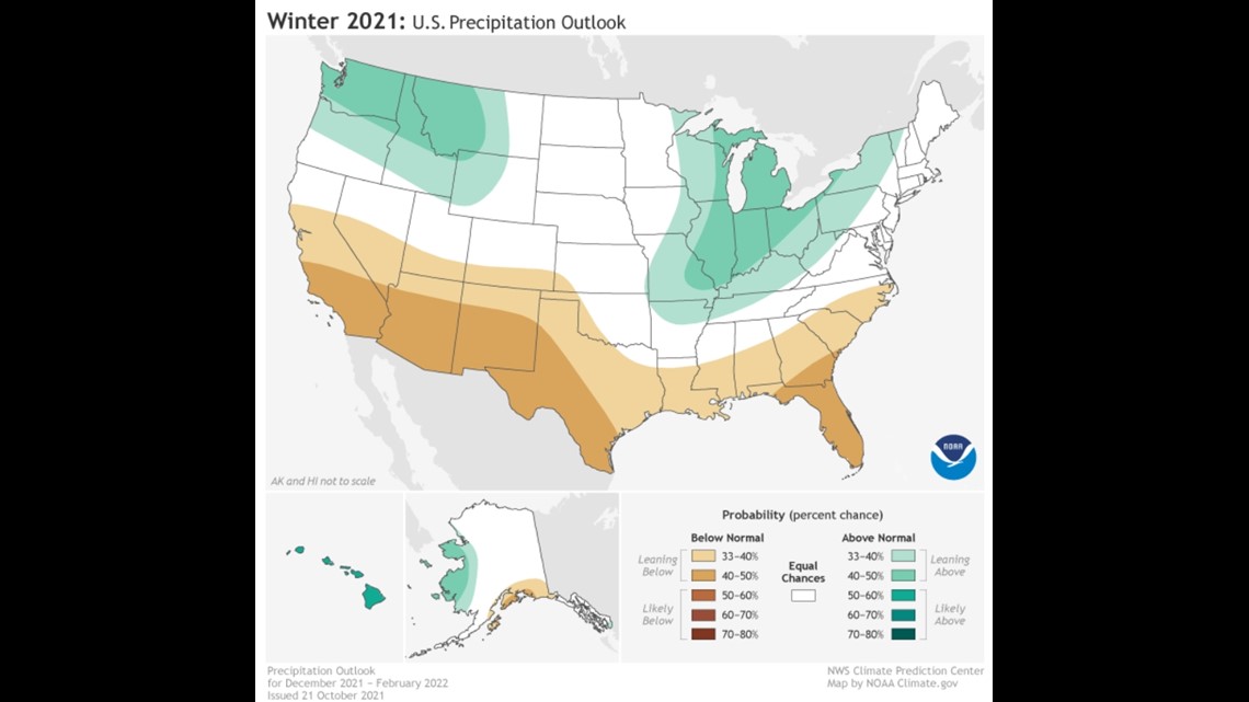

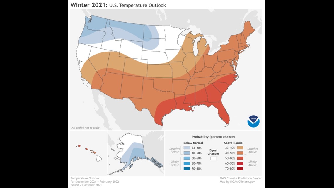
The graphic in the previous section shows weather conditions during a Quad Cities La Niña winter located just on the outer edge of wetter conditions.
In the winter outlook above, the Quad Cities are leaning above normal. This correlates with what we are supposed to see here in the QC area during La Niña since we are barely in the wetter zone.
Therefore, we should see a slight increase in snow but not unusually greater than average snowfall amounts. The same goes for temperature we are not directly under or at the edge of the colder section of the La Niña but next to it.
So, it is not surprising that we will experience slightly above normal temperatures for the winter.

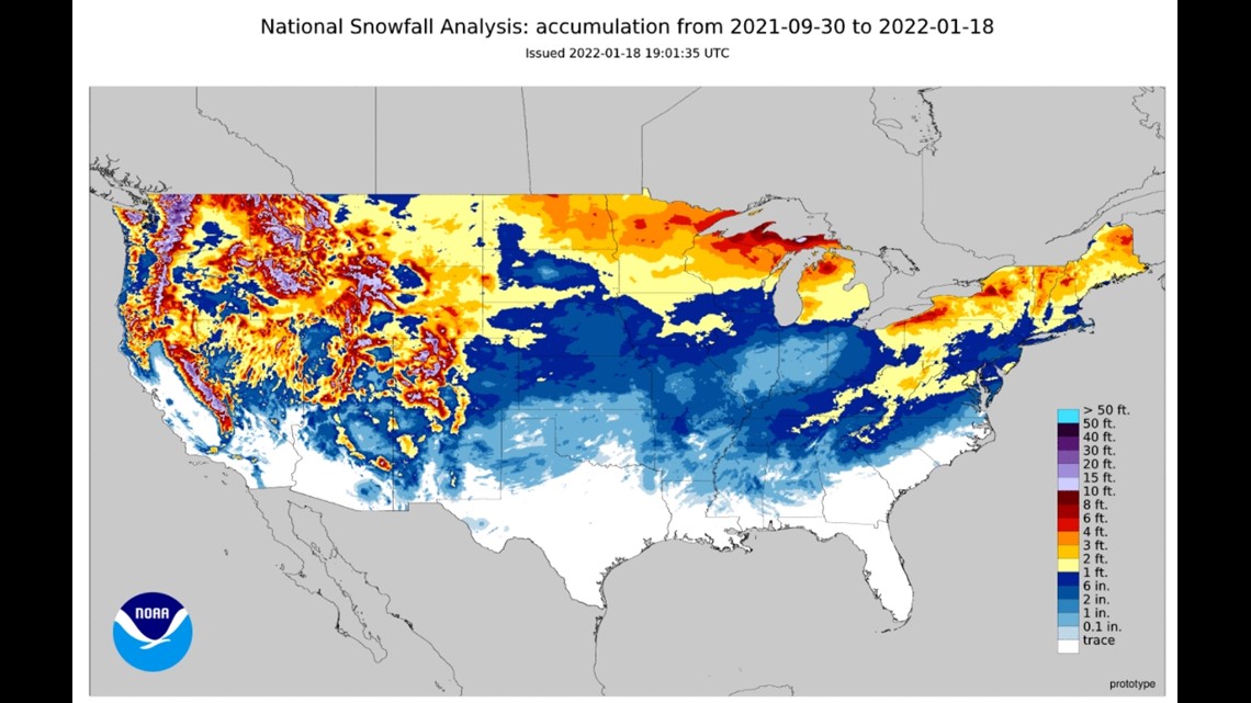
So far in the month of January, the National Weather Service has reported that moline has experienced 9.6 inches of snow when the average is usually 10.8 inches in January.
The chances that we will experience some snow before the end of the month is very low. Long range models show that February may start out with some snow.
The average snowfall for February is 8.6 inches. On average we experience 28.2 inches of snow during the winter. We are currently short of our average and that is due to there being only 3.3 inches of snow in December, on average we experience 8.8 inches of snow during that month.
The farmers almanac is reporting far more snow days, but it is unclear just how much we will see.
For us to have a slightly above normal snowfall, there needs to be just an extra inch (29.2) for this winter we need to experience 16.3 inches of snow in February.
If that occurs, then we can confidently say we experienced a La Niña winter.