
MOLINE, Ill. — Our first trace of snow for the fall season has already been observed here in the Quad Cities and it won't be long before we pick up something heavier in the weeks and months ahead. The recent cold snap has many of us thinking about snow and when we can expect the first significant round of it. Ronald from Galesburg had a great question and observation, asking, "Is the first measurable snow of the season getting later?" Let's dig in!
Yes, there is a trend pushing significant snow back
As discussed, the fall season is getting longer thanks to our changing climate. We're seeing more warmth extend throughout October, November, and even December. That warmth makes it harder for snow to fall, let alone stick because you are still dealing with warm ground.
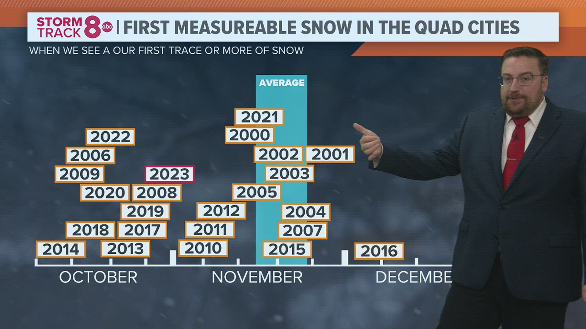
Our first trace of snow in the last several years has been observed very much ahead of the last 0.1" of snow average, which lands in the middle of November for the Quad Cities. Interestingly enough, even the average 1"+ snowfall date is later than most may think, landing on December 5 for Moline.

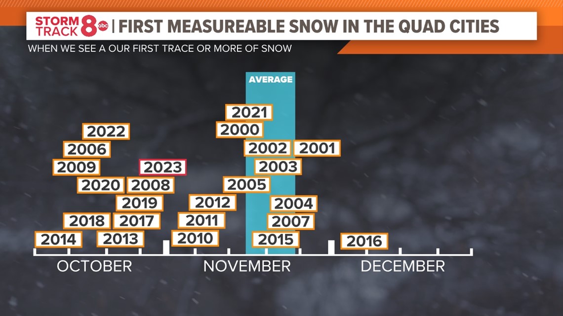
The plot above shows our most recent dates for the first trace of snow or more for October through December. Most of the last few years have had dates that are near the average.
Despite the warmth, the snow amount trend is increasing
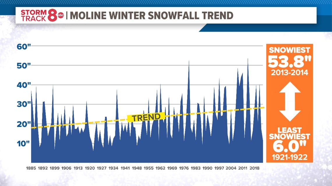
Now, here is something that many of you may disagree with, and I think I know why. When you compare the total snowfall amount for past seasons versus the most recent, the trend is actually up. Yes, you read that correctly. We are seeing more snowfall on average during the winter season now versus decades ago. The data doesn't lie! Take a look at the trend line below. Remember, we are talking about the ENTIRE winter season, which is December through February, not just an individual snowstorm.

So, the reason why it may not feel that way? It's been a while since we've had a doozy of a snowstorm. Take a look at these snowiest "1 Day" totals for Moline from the National Weather Service. It has been a while since we saw a whopper of a system, at least here in the Quad Cities.
- Jan. 3, 1971- 16.4"
- Jan. 19, 1995- 15.1"
- Feb. 1, 2011- 14.8"
- Jan. 13, 1979- 14.8"
- Feb. 1, 2015 and Nov. 26, 2018- 13.8"
- April 11, 1997- 12.1"
- Jan. 26, 1967- 11.7"
- Jan. 25, 1898- 11.0"
- Feb. 3, 1901- 10.0"
- March 29, 1972- 9.8"
Similarly, Dubuque:
- March 5, 1959- 15.0"
- Dec. 3, 1990- 13.7"
- Dec. 1, 1985- 12.8"
- March 8, 1961- 11.7"
- March 12, 1991- 11.2"
- Jan. 13, 1979- 11.0"
- Dec. 20, 2012- 10.6"
- Feb. 1, 2011- 10.6"
- Jan. 26, 1996- 10.3"
- Nov. 25, 1992- 10.3"
It's the frequency of "big snowmakers" that has changed which is why I believe many of us often comment about our winter just not being the same as a few decades ago. As has been the case recently, in order to get a higher seasonal snowfall total for the year, we bring in smaller events more frequently that add up over time to larger snowfall totals for the season, rather than getting it all at once with an individual storm. Makes sense!
So, why the increase in seasonal snowfall of winter is warming?
One thing to keep in mind is that as our planet warms, it is capable of holding more moisture. More moisture equates to more rain or in this case, snow!
Have a question you would like me to answer for an upcoming Ask Andrew segment? Submit it, here.