

DAVENPORT, Iowa — Whether it's on our phones or on the air here at WQAD, all of us receive some type of alert when severe weather threatens. Now, the National Weather Service is looking to enhance those alerts with a new warning system called, Threats in Motion.
"We try to provide as much lead time for everyone as possible.", says Rich Kinney, Warning Coordination Meteorologist at the National Weather Service in the Quad Cities. "With the radar, the new GOES satellite data and observational data, we sort of link all of that together and really come up with a new way of issuing warnings that we feel will have a lot of benefits to the public."
Before 2007, anytime a tornado, severe thunderstorm, or flash flood warning was issued, an entire county would be placed under a warning. This created an abundance of people that were being "over warned".
From 2007 to know, polygons are used, limiting the coverage of the warning to a smaller area where most of the impacts would be seen. Still, there lies a problem with the current polygon system.
"That polygon is static. It does not move. The storm moves through the warning polygon and if the threat continues and you need to issue another downstream warning, you may not be providing the same kind of lead time for folks in one warning versus another.", says Kinney.
Now, thanks to the help of advanced technology and more powerful computing equipment, the next generation of severe weather warnings looks to not only give the public more time to take shelter but also fine-tune the exact threats that specific storms will bring.
So, what's changing? Nearly everything.

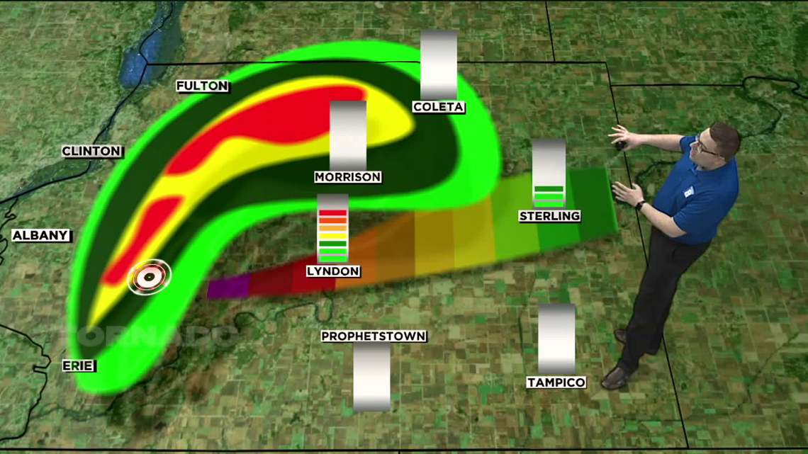
In this example, instead of a polygon, a threat "heat map" is used extending outward directly from the threat, in this case, a tornado. Those locations closest to the threat will have a very high probability on the scale, while downstream locations will have low probabilities. The scale itself would be from 0 to 100, 100 being the highest threat area. At the same time, this "heat map" will be moving in real-time, with the probability scales adjusting along the way.
Because the warning is actively moving in real-time, it also means locations within the path of dangerous weather will receive a more even spread of warning time. With the current system, a location on the outermost edge of the polygon may get up to 30 minutes of warning time, while a location outside of the polygon may only receive 10 to 15 minutes of warning time once a new warning is issued.
"The motivating factor is not simply to just increase lead time but to provide more equitable lead time to everyone.", says Kodi Berry, FACETS Program Lead/NOAA. The FACETS program is the next generation of warning and forecast technology.
Berry has been leading the program that is currently developing and testing the new Threats in Motion concept. Currently, in testing, the new program also includes data taken from several social science experiments.
"These social studies have found that when provided probabilistic weather information, people make better decisions. The key is just making sure that it is defined in a way that makes sense to the person using it.", says Berry.
When can we expect to see the new Threats in Motion warning system right here in the Quad Cities? "We still have some software development and some social science research to do, so we are hoping that the rapidly updating warnings, within five years would be a reality.", says Berry.
Meteorologists both on and off-air are currently testing the system at the National Severe Storms Laboratory in Norman, Oklahoma.
New technology is also being tested that would allow rapidly updating warnings to be sent to many popular weather apps, including the WQAD News 8 App.
A more in-depth interview with Kodi Berry is now available exclusively on our Head in the Clouds podcast.

NOAA has also released this tutorial on their YouTube channel which explains how the new system will work.