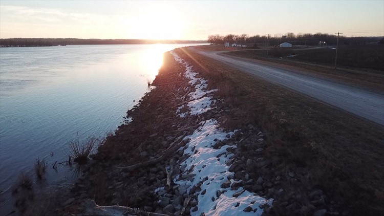
DALLAS CITY, Illinois-- A proposed levee increase near Wever, Iowa is stirring concerns across the Mississippi River.
The Green Bay Levee and Drainage District No. 2 is asking the U.S. Army Corps of Engineers to authorize a four foot increase. The levee is already three feet taller in some areas than it's currently allowed. The drainage district wants to add another foot to protect 15,138 acres of farmland and 34 homes.
But some people living on the Illinois side of the Mississippi worry it could mean more flooding for them.
"The proposal that's going on across the river, that would just put us in that much more jeopardy," says Kevin Six, the mayor of Dallas City. "I put the word out around town pretty good, and believe me that got everybody up, because what we went through the last two (floods), nobody wants to do again."
Dallas City was hit hard by the historic floods in 1993 and 2008. Mayor Six says even a few more inches of flooding could be devastating.
"You don't know what's gonna happen next when (the river) comes up," Six says.
Craig Beck, the owner of Ike's Riverfront Tavern, says the road leading to his restaurant was flooded just a few months ago, stopping people from coming in.
"(A levee increase is) actually gonna effect just about everybody from Fort Madison all the way up to the dam," he says. "It's gonna wipe out a lot of communities. It's going to disrupt life for a lot of folks."
Beck and Six say the city can't keep up with rising flood levels.
"We might be able to go and sandbag for a day or two, but to sit there and sandbag for days and days and possibly weeks at a time, it's an impossibility," Beck says.
The Green Bay Levee and Drainage District No. 2 had a study done on the potential impact of the levee. It shows some cities along the Mississippi could see nearly five more inches of flooding with the levee increase. But that's during a flood worse than 2008. It's based on a flood 20 percent worse than a 500-year flood. Dallas City would see about five more inches at that flood stage.
"So we've never seen a river this high. Will we ever see a river this high? We don't know," says Mike Walker, chairman for the drainage district. "The recent history is showing us that our levee system is not high enough to handle the amount of water we've been seeing the last 20 years."
Walker estimates water could rise 30-60 feet more in some areas in Dallas City with a levee increase than it normally would during a 500-year flood.
The study does include a "maximum water surface impact." Should the Mississippi River rise enough to reach the top of the proposed levee height, some cities could see an additional one and a half feet of flooding.
Walker says he can understand why his neighbors are so concerned.
"If the water gets up three inches in your house, and you're gonna increase it an inch, to you it's a big deal," he says.
Walker says the drainage district is just being proactive.
"Due to the frequency and severity of rivers in the last 20 years, everyone in the upper Mississippi, we believe, needs to be more proactive," he says.
Walker says if the U.S. Army Corps of Engineers approves the levee proposal, the levee would meet minimum FEMA requirements, affecting the drainage district's insurance rates.
Mayor Six says a levee along Dallas City would costly and difficult to build. For now, he says his community has to rely on sandbagging.
Beck says an aging population could make that task even harder.
The U.S. Army Corps of Engineers accepted public comments for the proposal in October and November. It's expected to make a decision after the first of the year.