Everything you need to know about Mississippi River levels
We are keeping an eye on rising river levels this week. Because many of our waterways will reach or exceed major flood stage, we want to make sure you find all ...
mississippiriver
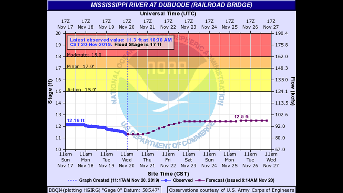
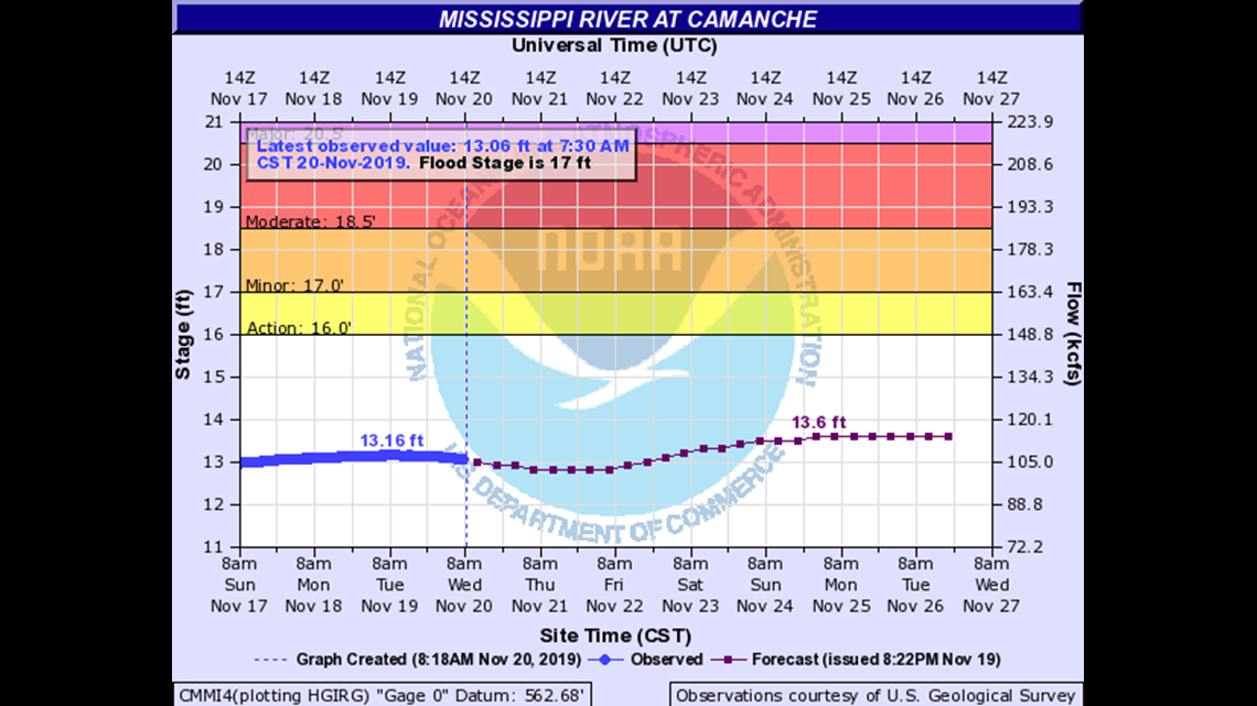
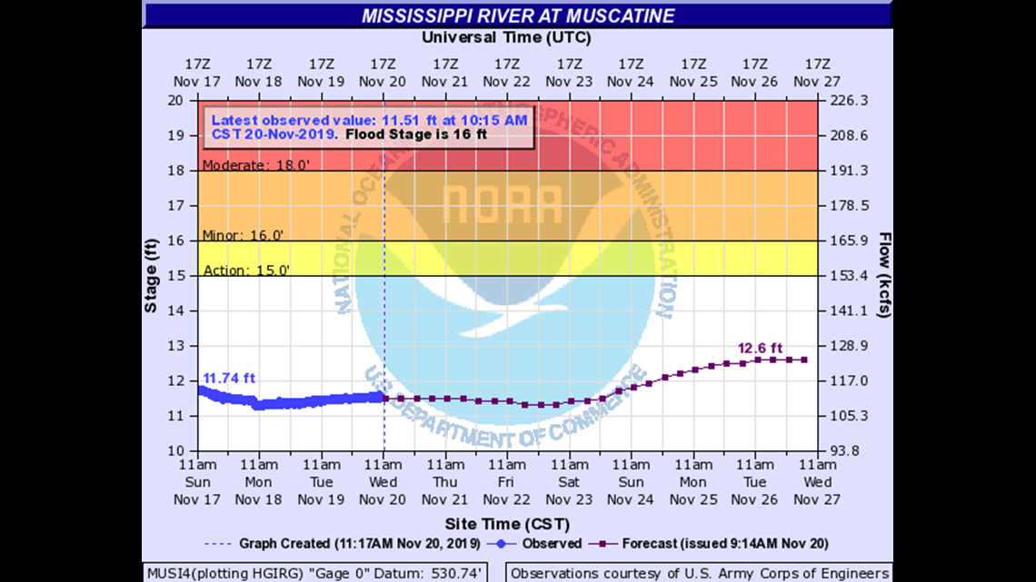
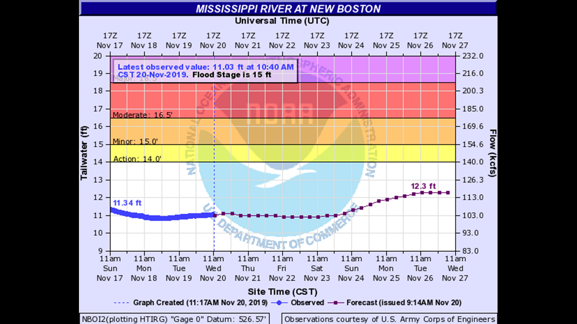
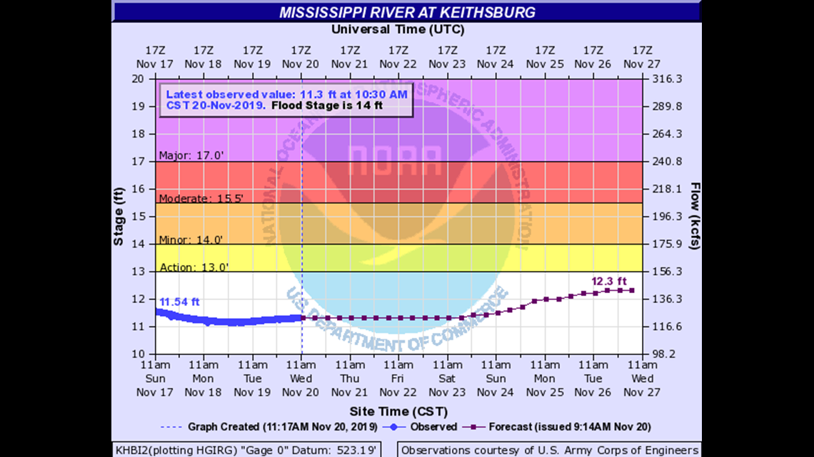
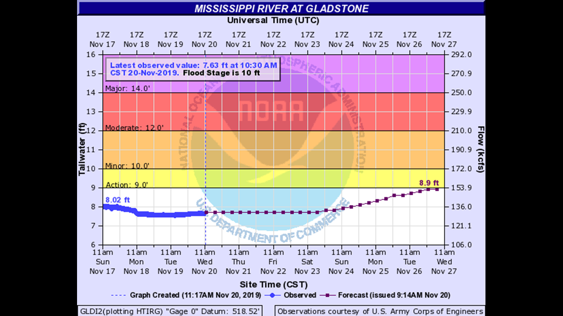
Because many of our waterways will reach or exceed major flood stage, we want to make sure you find all of the river forecast information you’re looking for. Below, the forecast crest graphs from the National Weather Service and the impact that level of flooding will have on surrounding areas.
Everything you need to know about Mississippi River levels
20.5
Water affects the Illinois Central railroad tracks in Dubuque.
20
Water reaches the base of the flood wall at the Ice Harbor. Most of the houses on the river side of the East Dubuque levee are in water.
18
Water overtops the East Dubuque Flats levee.
17.5
Water affects Basten Road in East Dubuque.
17
Water affects homes in Shore Acres in East Dubuque.
15
Water affects yards in East Dubuques Shore Acres subdivision.
14
Water inundates the lower end of City Island. Water is at the edge of the Shore Acres subdivision and the Bent Prop Marina area in East Dubuque.
Everything you need to know about Mississippi River levels
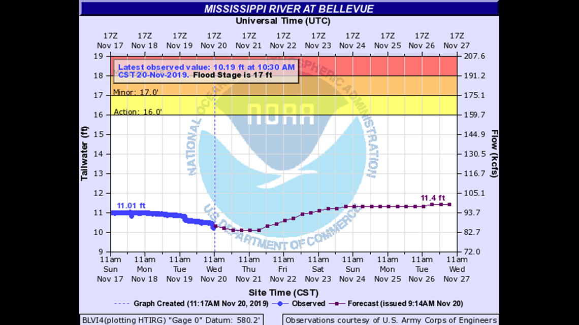
18
Water affects the riverfront parking lot in Savanna. Water affects the boat launch at North Sabula Access in Sabula. There is also seepage into basements, yards, and gutters.
17.8
Water affects Spruce Creek Park on the north end of Bellevue.
17.5
Water affects a few homes south of Bellevue. Water affects operations at a grain elevator in Savanna. Water affects the lowest businesses in Sabula.
17.39
Water affects businesses on North River Drive in Sabula.
17.3
Water affects the railroad underpass at Mill Creek in Bellevue.
17
Rural damage occurs near Bellevue.
16.5
Water affects a convenience store on the south end of Bellevue east of Ridgeview. Water is also at the base of foundations of the lowest businesses on Riverview near Jefferson St.
14
Water affects the camping areas at Blanding Landing and Pleasant Creek Recreation Areas.
Everything you need to know about Mississippi River levels
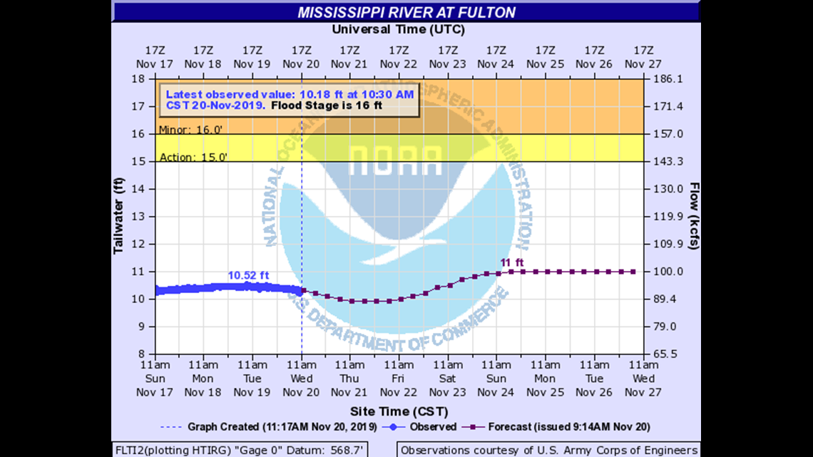
19
At Sabula, which is 18 feet on the local gage, water affects South Avenue at the levee and the lowest section of Lake Street.
18.98
Lock and Dam 13 is closed.
18
Water affects businesses on Sabulas North River Drive.
16
Water affects a few houses at Thomson.
Everything you need to know about Mississippi River levels
21
Water affects many homes in Camanche and is at the base of the Camanche water treatment plant.
20
Water affects South Washington Boulevard in Camanche. Water also affects the Camanche Marina. Water also affects several homes in Albany.
19.5
Water affects marina facilities at River View Park in Clinton.
19
Water affects homes in the Camanche Swan Slough area, the boat ramp, and 9th Street by Hazel Lake. Water affects Union Pacific Railroad maintenance buildings in Clinton.
17
Water affects low-lying residences at Albany.
16.5
Water affects the city owned baseball stadium in Clinton.
Everything you need to know about Mississippi River levels
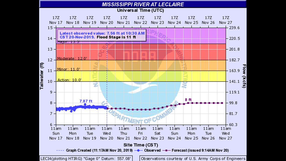
13.99
Lock and Dam 14 is closed.
13.7
Water affects East Harbor Drive in Bettendorf.
13.5
Water affects First Street in Rapids City.
13.4
Water affects Princeton’s River Drive.
13
Water affects Riverside Park in Le Claire.
12.5
Water affects the lowest residences at the upstream end of town in Hampton.
12.2
Water affects 182nd Street in Pleasant Valley.
12
Water affects the lowest houses along the Princeton river front. Water affects several local roads on Campbell’s Island and is at the foundations of a few homes. In Pleasant Valley, water is at the bases of or in many houses along the river.
11.4
Water affects 245th Avenue in Pleasant Valley.
11
Water affects the lowest roads and into some back yards on Campbells Island. In Pleasant Valley, water affects 179th Street and at the bases of a few homes along the river. In Cordova, water affects the lowest homes along the river.
10.5
Water affects 178th Street in Pleasant Valley.
10
Water affects low areas in Pleasant Valley.
Everything you need to know about Mississippi River levels
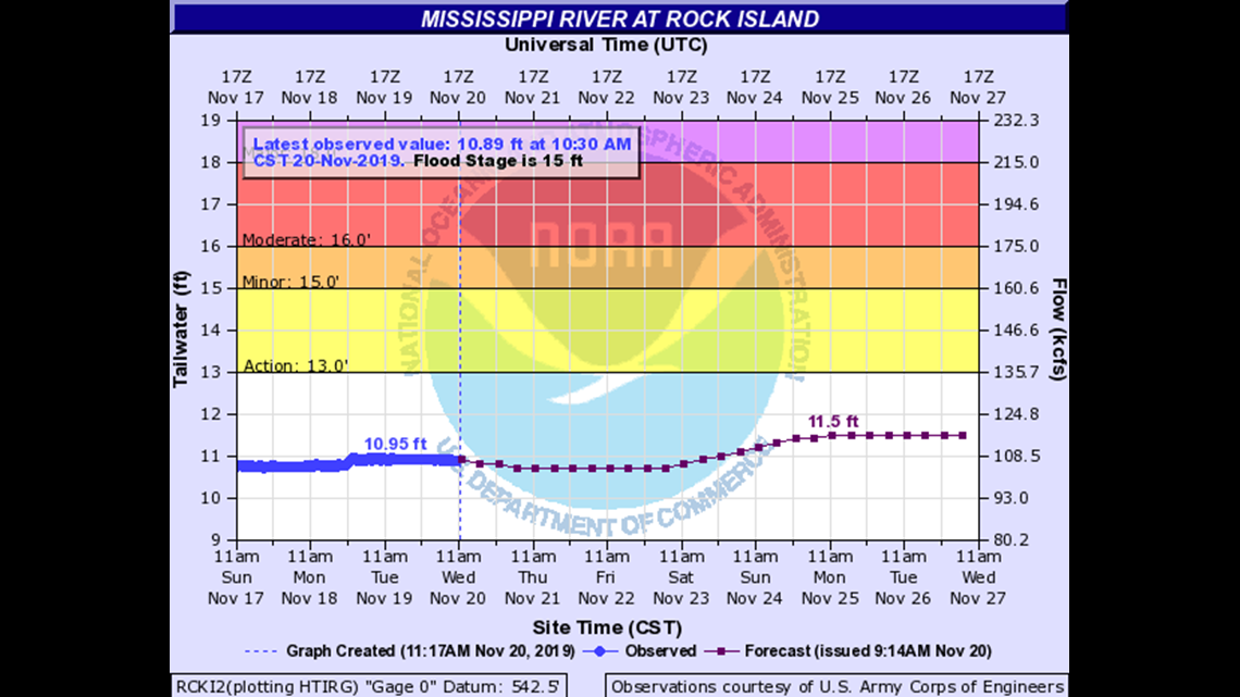
17.5
Water affects the railroad tracks in downtown Davenport and River Drive, Pershing Avenue, and Federal Street. Water affects Bettendorf’s Leach Park.
17
Water is over most of Davenport’s Le Claire Park and lower parking lots.
16.5
Water affects Credit Island Lane in Davenport and the 4700 block of River Drive in Moline. Water is at the base of the flood wall gates at the downtown Rock Island riverfront.
16
Water affects sidewalks along the river at Le Claire Park. Water also affects Credit Island Lane and Moline’s River Drive in the 4700 block.
15.5
Water affects Le Claire Park.
15
Water affects several sections of South Concord Street south of River Drive in Davenport and is at the foundations of several homes on Enchanted Island. Water also affects industries along the river at the south end of Davenport.
Everything you need to know about Mississippi River levels
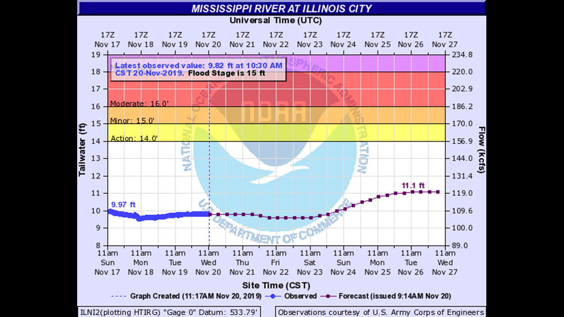
8
Water affects the state park campground at Fairport.
17
Water affects the Buffalo Shores Access Area.
16.98
Lock and Dam 16 is closed.
16
Water affects the park at Andalusia.
13
Water affects residents on Smiths Island.
Everything you need to know about Mississippi River levels
21
Riverside Park is entirely under water.
20.5
Water affects Mississippi Drive at Mulberry Street.
20
Water affects 5th Street at the Mad Creek bridge as well as the Pearl Street Station.
19.5
Water affects industries just north of the flood wall along Mad Creek.
19
Water affects marina buildings in Muscatine. Water affects Mississippi Drive at Walnut Street.
18
Water affects most of the Riverside Park parking lot.
16
Water affects the lower portion of the Riverside Park parking lot.
Everything you need to know about Mississippi River levels
21
Water affects grain elevators in New Boston.
20.6
The Lake Odessa levee overtops.
18.1
Lock and Dam 17 is closed.
Everything you need to know about Mississippi River levels
19.5
Water affects the Illinois Power facilities along Marina Drive in Oquawka.
19
Seepage behind Keithsburgs levee affects businesses on 4th Street and affects Keithsburg Road at Pope Creek.
18.5
Water affects Oquawkas Marina Drive just south of town.
18
Water is over Pope street north of Keithsburg.
17.5
Water affects most houses on 1st Street in Oquawka.
17
Seepage behind Keithsburgs levee affects Jackson Avenue south of 4th Street.
16.5
Water affects houses on 1st Street in Oquawka.
16
Water is over the campground and boat ramp in Keithsburg.
Everything you need to know about Mississippi River levels
17
Water reaches the tops of the levees at the Henderson Drainage District.
15
Lock and Dam 18 is closed.
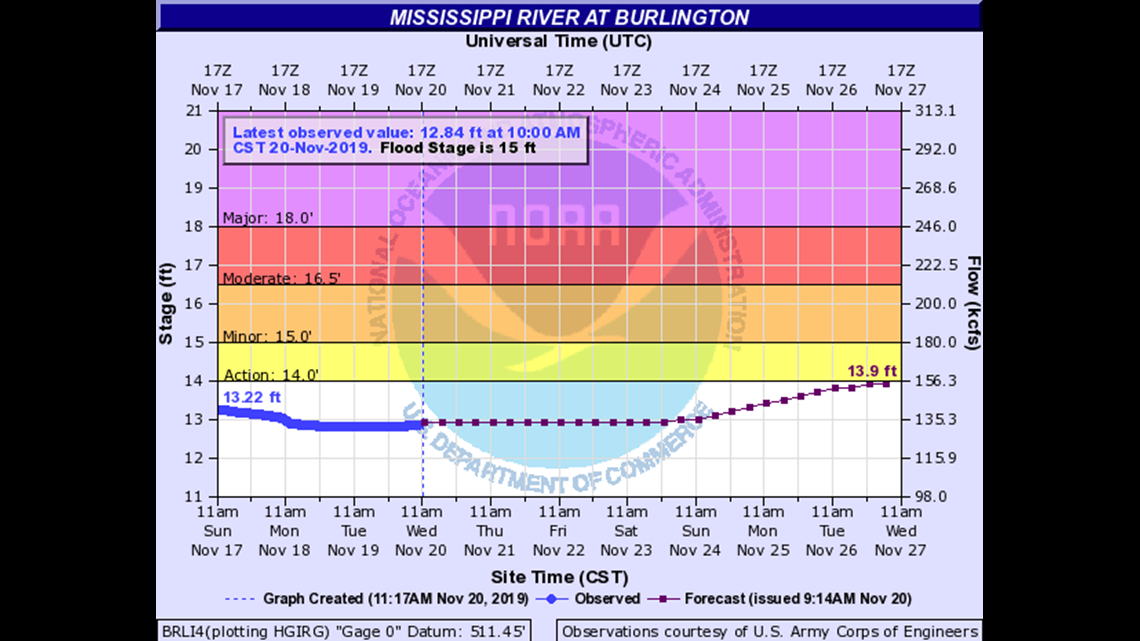
Everything you need to know about Mississippi River levels
20.5
Water affects several homes on First Street in Dallas City. Water also reaches the top of the Niota town levee.
20
Water reaches the front steps of the Burlington Municipal Auditorium and affects the parking lot. Water affects industries at the south end of town. Water affects most of Riverview Park in Fort Madison.
19.5
Water affects the Port of Burlington. Water affects residences on First Street in Dallas City. Water also affects Illinois Highway 96 between Niota and Dallas City. Water also affects several homes in Pontoosuc.
19
Water causes drive and access problems to a restaurant along the river. Water also goes over the new seawall on the riverfront. Water affects streets bordering the river in Pontoosuc.
18.5
Water is over the bank south of the Burlington auditorium. Water also reaches the base of Old Fort Madison.
18
Water affects the Burlington Auditorium parking lot. Water also affects Bluff Harbor Marina. Water affects North Shore Marina in Fort Madison. In Dallas City, water affects First Street at the ball park.
17.5
Water affects Riverview Drive in Riverview Park in Fort Madison.
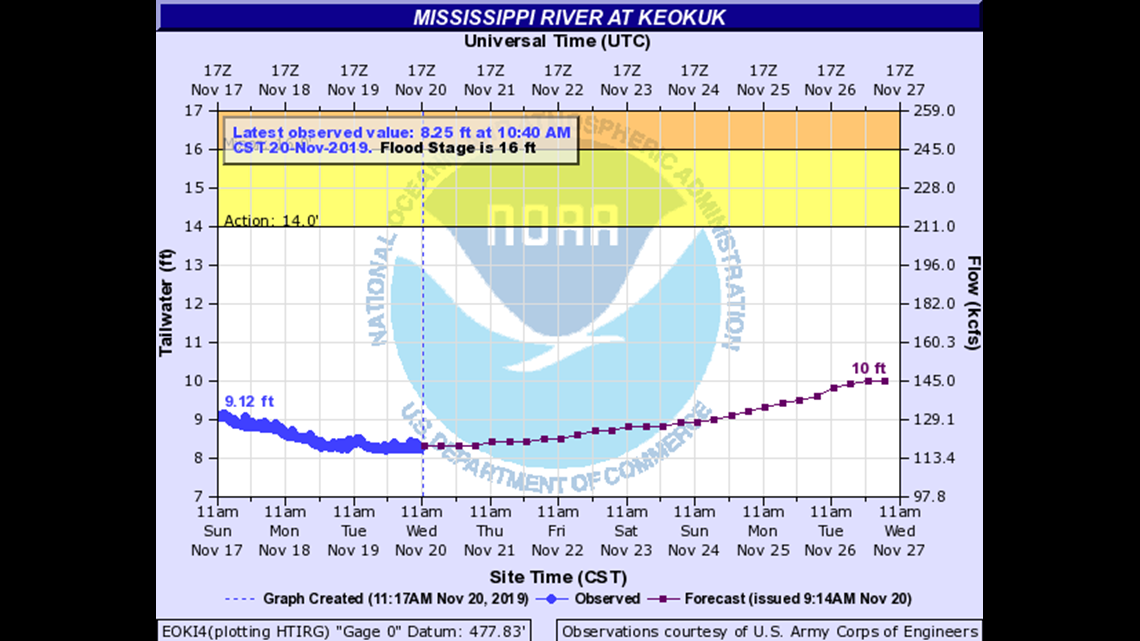
Everything you need to know about Mississippi River levels
19.5
Water reaches critical stage for Des Moines and Mississippi Levee District Number 1.
19
Water affects low lying buildings in Warsaw and affects County Road 12.
18.4
U.S. Highway 61 closes at the bridge over the Des Moines River north of Alexandria.
16
Water affects low lying buildings in rural areas. Water affects the railroad tracks in Alexandria.