MOLINE, Ill. — WQAD News 8 is now on Roku and Amazon Fire TV. Download the apps today to stream live newscasts and watch live video on demand.
Folks in the Quad Cities are preparing for a winter storm to hit just ahead of Christmas weekend. StormTrack8 has been watching the system's development and is anticipating that it'll hit by Thursday morning.
An intense snow squall is expected to arrive in the Quad Cities area by 8 a.m. Thursday. This line will bring in a band of heavy snow, strong winds, reduced visibility and a flash freeze.
Meteorologist Andrew Stutzke had a winter storm discussion Thursday morning to go over the latest details, you can watch that below:
When will it start snowing? How much will it snow?
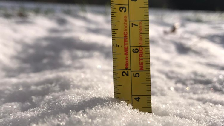
Snow is already falling in the Quad Cities Thursday morning. StormTrack8 says snow will stop falling around the noon hour, overall totaling just a few inches.
As of about 7 a.m., snowfall reports out west have been coming in at 2-2.5 inches.
How will the wind be?
Cold and strong! Winds will continue to increase throughout Thursday as temps fall below zero in the early afternoon. By the evening, whiteout conditions are likely at times, especially in open areas with very little shelter.
Wind chills will also be dangerously low Thursday evening through at least the start of the weekend, dipping down to -40° at times. The actual temp will drop to around -7°. Make sure to keep an eye on your pets — if you're cold, then they're cold!
And take care of yourself as well. Frostbite can happen within 10 minutes if skin is exposed in these terribly chilling temps!
Remember, a Blizzard Warning is defined by wind and visibility and not snowfall amounts.
StormTrack8 predicts the bitter cold and dangerous wind chills to continue through Sunday, or Christmas Day. However, travelers should expect better conditions by Saturday afternoon.
When is the best time to travel?
If you have plans to travel between Thursday and Friday, it may be best to reassess and travel another day. Dangerous wind chills along with blowing/drifting snow will continue through nearly the entire day Friday. Travel will remain very difficult as wind chills continue to range from -25° to -30° at times.
Lighter winds and better travel conditions are expected by later Saturday morning and will continue through Christmas Day. Wind chills will still be flirting with -20° at times, but by Sunday we should see warmer values return.
If you absolutely need to travel, be prepared. Pack a winter weather survival kit in your car that includes a shovel, extra blankets, water, snacks, cell phone chargers and some kind of traction aid, like sand or cat litter, should you get stuck in the snow.
Stay weather aware this week
Watch more news, weather and sports on News 8's YouTube channel