
Late last week, our weather team began observing signs of a healthy area of low pressure for this week.
Our reliable computer models, such as the American GFS model and the European ECMWF began to show consistency over the weekend which led us to have higher confidence in a big snow.
But this forecast would go from "doozy" to "dud" quickly.
So, what happened?
The answer is something we all need to understand so we can be better prepared moving forward.
Historically, we know some of our biggest snowstorms occur this time of year as the atmosphere in late February can obtain more moisture than the colder, drier months of December and January.
This past weekend, it originally looked like Northern Iowa and Central Wisconsin would get the brunt of the snow.
Then, it shifted south.
Then it shifted south again.
Many Meteorologists (including yours truly) can't remember a time when models made such an abrupt shift on the map and in intensity.

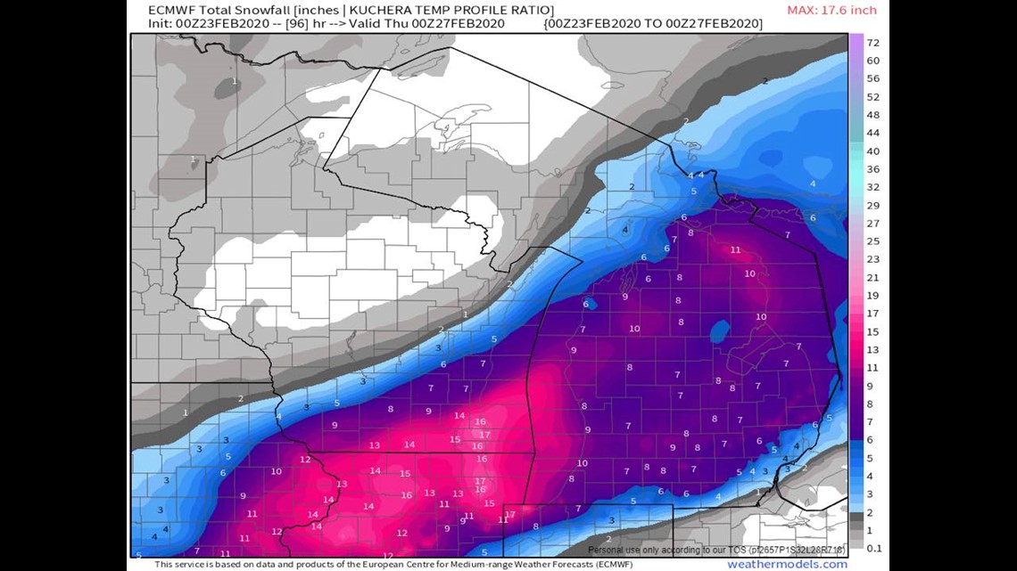
Over the weekend, we had some really incredible amounts showing up.
This particular run of the ECMWF model showed more than a foot of snow for Eastern Iowa into Southeastern Wisconsin.

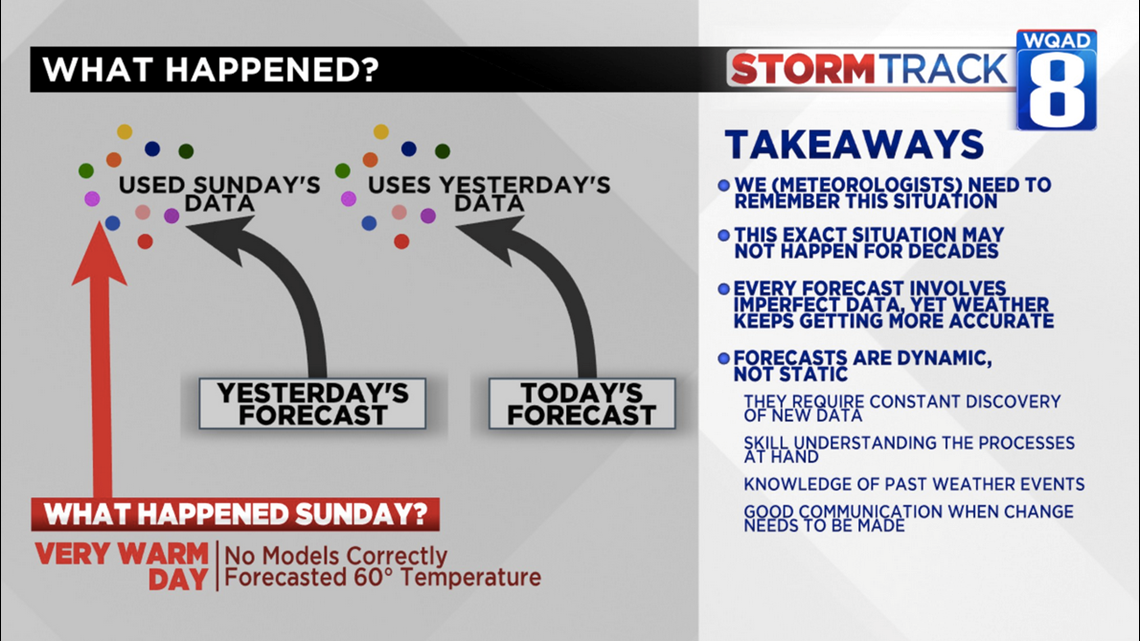
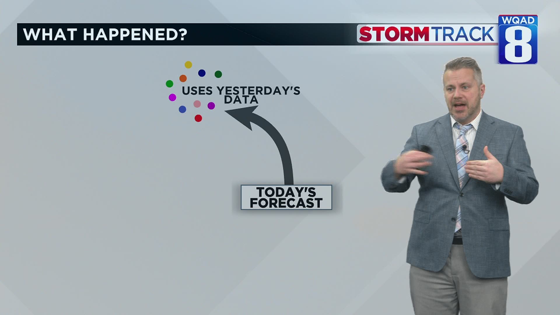
In order to understand how weather forecasting works, we must focus on where the information in these models comes from. The morning's weather forecast is made using data collected yesterday.
So, Monday's forecast was made using data collected Sunday.
The QC hit 60 degrees on Sunday.
Not one of our computer models had that solution occurring. That meant that some bad data went into the forecast equation. If you have just a little bit of bad data going in, you can assume that bad data will come out.
There was probably some bad data from upper-air data as well, since the incoming system was arriving from Western Canada (where there are fewer remote sensing data collectors).
So why didn't we pick up on the error?
Meteorologists throw out the outlier solutions with regularity, but when we see consistency from model to model and run to run, we have to assume some level of accuracy.
This snow forecast all relied on one low pressure system merging with another in a process called "phasing". Phasing is often a critical process for large amounts of snows to fall and it did not happen.
Where do we go from here?
First, Meteorologists need to remember situations like this. We need to remember how the forecast went wrong so we can identify it again when it happens.
I've learned some things concerning the dynamics of severe weather and tornadogenesis that I didn't have in my repertoire a few years ago. We always need learning.
The trouble is that this same situation may not happen again for a decade or more when a new Meteorologist will likely be sitting here when it happens.
Second, every weather forecast involves imperfect data but even with imperfect data our accuracy is increasing year to year. Forecasts are also very dynamic and not very static.
That means we make changes constantly.
While we would love to consistently have 100% accuracy, there are always discoveries to make as new data comes in. Sometimes that comes within 24 hours of the start of a big snowstorm.
Finally, we need to have good communication when change needs to be made. I think we excelled at that Monday and I'm thankful we never had to walk back any "alert days."
Last thoughts on this weather story
While the public expects us to have an accurate forecast every day -- which we track daily with our 3 Degree Guarantee -- sometimes changes happen after you received the message. Sometimes that happens after you've changed your plans.
As you go through the extra work of moving your schedule around, rest assured we are working hard on our time off so we have a better chance of getting it right.
Taking your grievance out on the team with condescending comments doesn't help us move the enterprise forward. If anything, it chips away at the determination we have.
We'll bring humility and the most accurate forecast if you give us the chance of optimism.
-Meteorologist Eric Sorensen