MOLINE, Ill. — A front heading east will generate a strong line of storms Sunday night for the Quad Cities, according to our StormTrack8 team.
The QC metro and south of I-80 are in a level 3 out of 5 threat for severe storms, including large hail, strong winds and tornadoes. The biggest concern will be the possible tornadoes and hail up to the size of 2 inches or more.
And in case you missed it, StormTrack8 Meteorologist Andrew Stutzke hosted a live severe weather discussion on News 8's YouTube page at 3:30 Sunday afternoon.
Make sure to stay weather aware by downloading News 8's app. You'll get the latest updates on the storms heading your way and be able to watch our live coverage even if your power goes out.
LATEST FORECAST: Strong storm threat this evening
LIVE UPDATES
10:31 p.m. | Tornado Warning issued for parts of Bureau and Putnam counties
This warning will last through 10:45 p.m. Make sure you are in your safe space!
10:12 p.m. | Severe Thunderstorm Warning issued for Kewanee, Galva and Wyanet
This warning will last through 10:45 p.m. and impacts parts of Henry and Bureau counties.
9:50 p.m. | Severe Thunderstorm Warning issued for Henry County
This warning will last through 10:15 p.m.
9:48 p.m. | Tornado Warning issued for parts of Hancock County
The warning will last until 10:15 p.m. A Severe Thunderstorm Warning continues for Kewanee, Geneseo and Cambridge until then as well.
9:45 p.m. | Severe storms to exit QC by 10 p.m.
NWS has received several reports of hail larger than 2 inches near Durant and I-80.
9:30 p.m. | Quarter-sized hail found near Sunbury

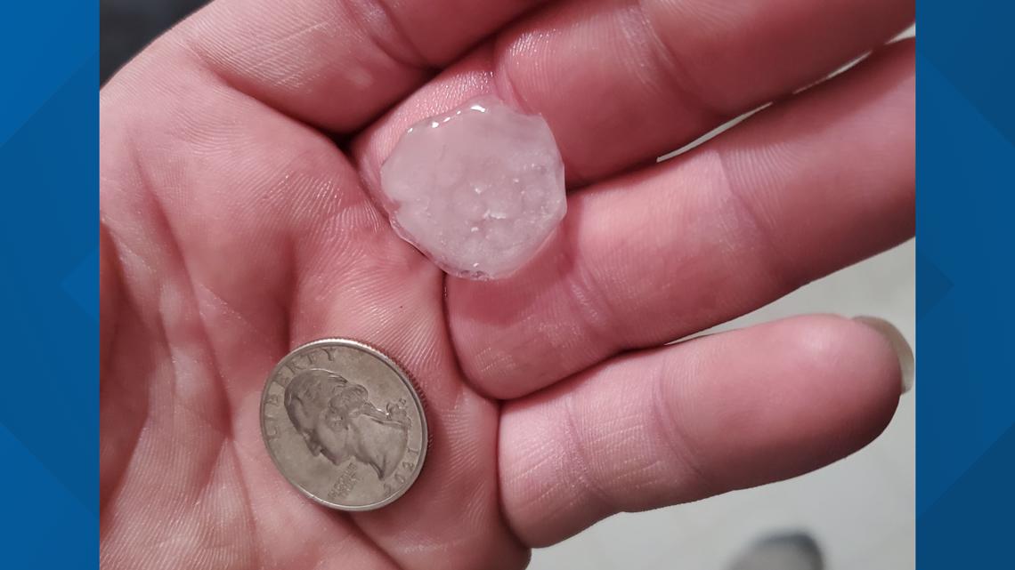
Tina Ferrel submitted her picture through the WQAD app.
9:29 p.m. | Severe Thunderstorm Warning issued for Rock Island, Milan and Coal Valley until 10:15 p.m.
The warning continues for Scott and Muscatine counties as well.
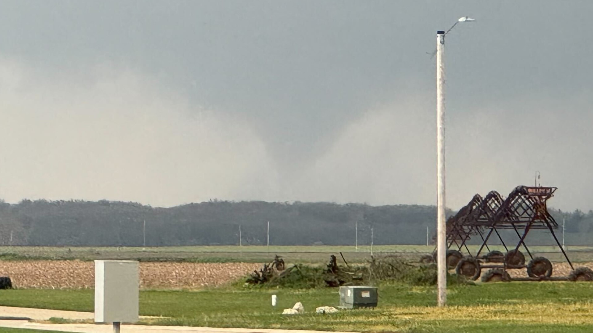
9:17 p.m. | Possible funnel clouds spotted near Davenport
StormTrack8 broke into Sunday evening programming following reports of a possible tornado near Davenport. The area will be under a Severe Thunderstorm Warning until 10 p.m.
Meanwhile, a Severe Thunderstorm Watch has been issued for areas near Galesburg until 4 a.m. Monday.
9:03 p.m. | Severe Thunderstorm Warning issued for Muscatine, Scott and Cedar counties
This warning will last until 9:30 p.m.
8:59 p.m. | Wilton, Durant and Walcott all under Severe Thunderstorm Warning
This warning is expected to last until 9:30 p.m. and could contain golfball-sized hail.
8:51 p.m. | NWS says 2-inch-sized hail is expected in Bennett, Rochester and Sunbury
The threat to the Iowa towns will last until 9 p.m.
8:34 p.m. | Severe Thunderstorm Warning issued for West Branch, Bennett and Rochester
All of these Iowa towns will be under the warning until 9 p.m. The NWS warns this storm will contain goofball-sized hail.
8:28 p.m. | Radar update from StormTrack8
8:20 p.m. | Severe Thunderstorm Warning issued for Henry, Bureau counties
This warning is expected to last until 9 p.m. The NWS says the storms are "rapidly increasing in coverage to the west and northwest of the QC metro."
8:18 p.m. | Severe Thunderstorm Warning issued for Kewanee, Galva and Cambridge
This warning is expected to last until 9 p.m.
8:09 p.m. | Severe Thunderstorm Warning issued for Lisbon, Mechanicsville and Clarence
This warning will last until 9 p.m., according to the NWS.
7:56 p.m. | Severe Thunderstorm Warning issued for North Liberty, Solon and Swisher
The storms are still pushing east towards the Quad Cities. This warning will last until 8:30.
7:45 p.m. | Radar update from the NWS
Meteorologists will be tracking this activity closely over the next hour.
7:19 p.m. | Tornado Warning issued for parts of Van Buren County
The NWS says the warning includes Keosauqua, Milton and Cantril. It is expected to last through 8 p.m.
7:05 p.m. | Tornado Warning issued for Davis County
The NWS says the storm is now moving southeast and will enter Van Buren County by 7:35 p.m.
6:11 p.m. | Tornado Watch issued for parts of Illinois, Iowa and Missouri
The watch will be in effect for this area until 12 a.m. Be prepared to take immediate shelter if a warning is issued for your area.
5:20 p.m. | Some showers and storms move through QC
The NWS of Quad Cities says it's not expecting any severe storms with this first quick round.
4:24 p.m. | Storms are still expected to be in the QC after 7 p.m.
Andrew says he suspects a Tornado Watch will be issued soon for the area south of Iowa City, east of Ottumwa and west of Galesburg.
4:05 p.m. | NWS says atmospheric conditions are becoming more favorable
Storms will be capable of producing all forms of weather hazards, like flooding, tornadoes, large hail and strong winds. Make sure you're weather-aware Sunday night!
3:30 p.m. | Andrew Stutzke hosts live severe weather discussion on News 8's YouTube channel
1:48 p.m. | NWS reminds region of enhanced risk of severe weather Sunday night
The NWS posts that the timing of severe storms could be between 6 p.m. and 1 a.m.
11:51 a.m. | Flash Flood watch placed for northeast Missouri, southeast Iowa and west-central Illinois
Saturday night brought in between 1-3 inches of rain across this area. Showers and storms Sunday night could bring 2-4 more inches.
10:04 a.m. | Damage you can expect from hail
Sunday night's storms have a large hail threat with them. Remember, even 1-inch diameter hail can cause damage!
9:53 a.m. | Tornado probability stretches from Ottumwa, Iowa to Galesburg, Illinois
The threat of a strong tornado does exist for areas in the red/hatch marks in Andrew's tweet below. This type of threat is extremely dangerous since storms are arriving after dark.
7:39 a.m. | Storm timing is roughly between 7 p.m. and midnight
StormTrack8's Andrew Stutzke advises everyone to have a way to receive warnings ahead of Sunday night's storms.
7:24 a.m. | QC area has a level 3 out of 5 risk for severe storms Sunday night
The timing of the storms at this point is between 5-11 p.m.
3:35 a.m. | NWS says conditions are favorable for "all modes of severe weather"
The National Weather Service of the Quad Cities notes there is an "Enhanced Risk" for severe storms forecast for locations along and south of Interstate 80 for Sunday.