
MOLINE, Ill. — With one more month left to go, it has been a relatively mild winter. But with February being the coldest month of the year, could we experience the arctic-cold temperatures associated with the Midwest?
The weather phenomenon that contributes to these cold temperatures is known as a polar vortex. A polar vortex, according to the National Weather Service, is a large area of low pressure and cold air surrounding both of Earth's poles. During winter, it can expand, move southward and bring cold artic air into Canada and the U.S.
The polar vortex is so large that it is divided into two parts: the tropospheric layer and stratospheric layer. The tropospheric layer is the lower half of the vortex, and the stratospheric layer is the upper part.
The tropospheric layer is where we actually experience the weather at the surface, while the stratospheric layer is where the weather is developed.
When you're in an airplane, you are at the top of the troposphere, and only some planes can go into the bottom of the stratosphere. This is the layer where our ozone is located as well as the stratospheric layer of the polar vortex. The remaining layers of the atmosphere after the stratosphere are the mesosphere, thermosphere and exosphere.
A strong polar vortex occurs when the cold air circulates around the poles. On maps that show air pressure, the darker colors around the poles look a donut. When the cold air is in a tight circle around the poles, we would experience a mild winter.
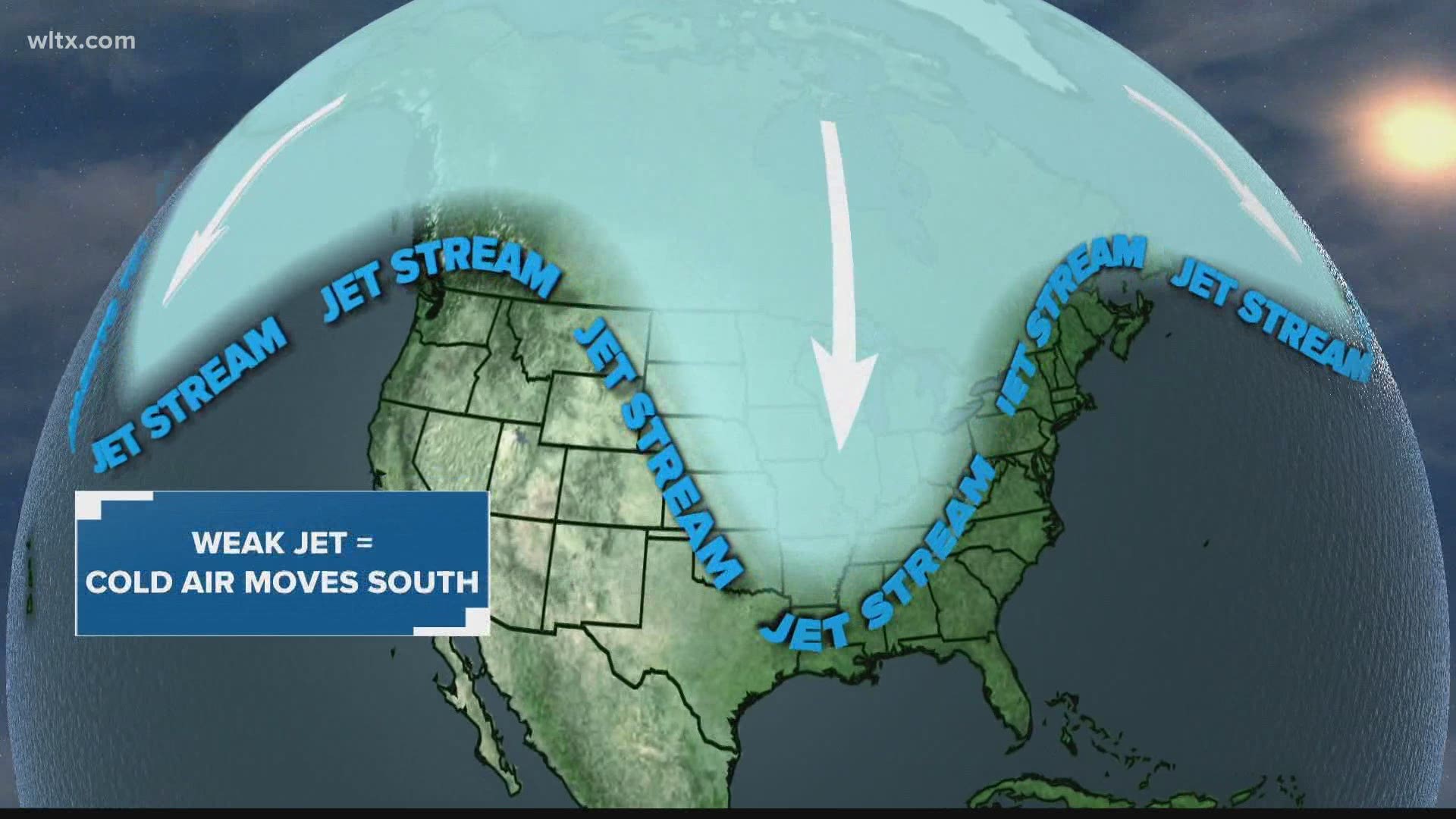
In a weak polar vortex, the cold air is not staying in a circular motion around the poles. It starts to move, creating a wavy look, or split apart. During a weak polar vortex, the cold air can dip down into Canada and the U.S., causing frigid temperatures, snow, etc.

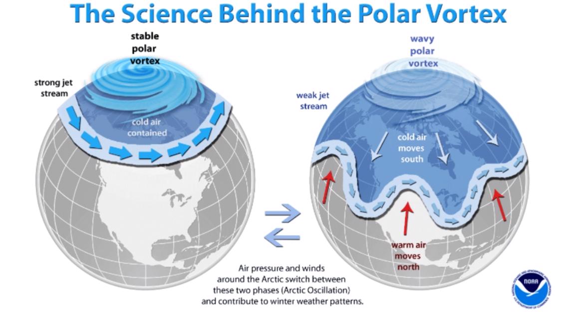
The polar vortex weakens in the summer and strengthens in the winter due to difference in temperatures at the poles and in-between areas. In the spring and summer, sunlight returns and results in warmer temperatures at the poles and in the stratosphere. Because of the warming at the poles and in the stratosphere, the temperature difference decreases between the north and south poles. The polar vortex can either disappear or collapse in a strong event.
The bigger the difference in the temperatures, such as in the winter when the temperatures at the poles and stratosphere decrease resulting in a big temperature difference with the south, the weaker the vortex becomes and the further south it moves or splits into pieces.
Polar vortex outlook through March
The European Centre for Medium-Range Weather Forecast produces global numerical weather predictions and diagrams predicting the how the polar vortex will change affecting temperatures we experience all the way throughout the month of March, which is the start of spring.
Starting with the remainder of February, the two graphs below will show the 500 hPa Z: weekly mean anomalies and the 2m temperature: weekly anomalies.
The first maps show pressure, the actual height of a pressure surface above mean sea-level. The cooler temperatures represent cold air masses and low pressure systems, and the warmer temperatures represent warmer air and high pressure systems. The temperatures, of course, show what our experience will be like.

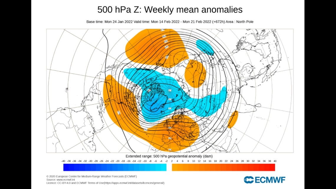

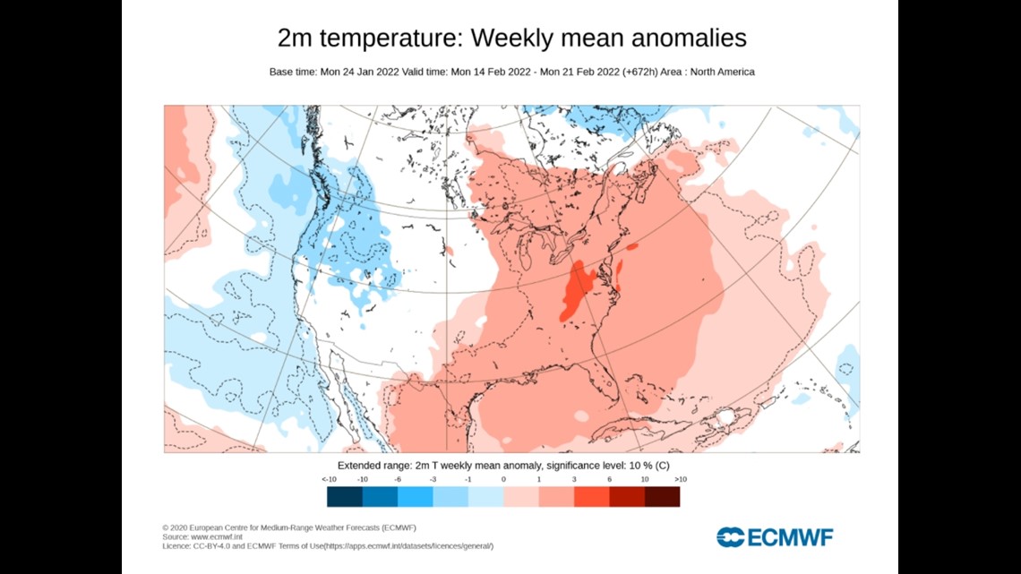
For February 14-21, the low pressure system is over the West Coast, which therefore will experience colder temperatures, and the East Coast will receive warmer temperatures.
The Quad Cities will experience relatively normal temperatures for the season, but there may be some days where we get slightly above that because we are right on the edge of the warm air mass.

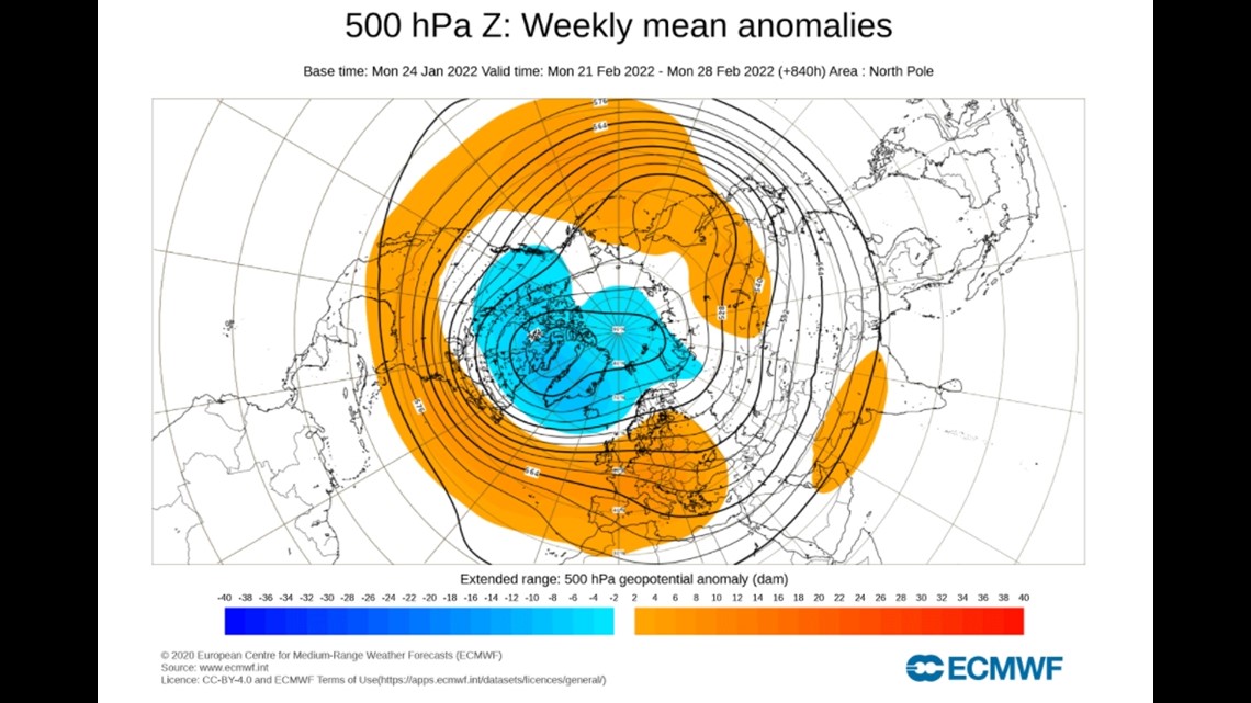

Near the end of month, the polar vortex is getting stronger, as the colder, lower pressure air is retreating northward and circulating.
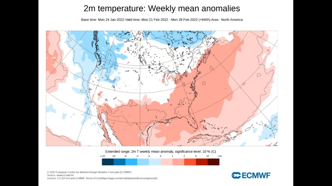
The southern and eastern half of the U.S will see warmer temperatures. The high pressure system will be over the eastern and southern parts of the U.S. However, the ECMWF does warn that we can see an extension of colder weather from the northwest to the Midwest. The temperature map shows the Northwest experiencing cooler temperatures because the tip of the low-pressure system is right at the North American/Canadian border. The Quad Cities is in the light red, high pressure parts of the maps, so we should see seasonal to slightly warmer than normal temperatures.

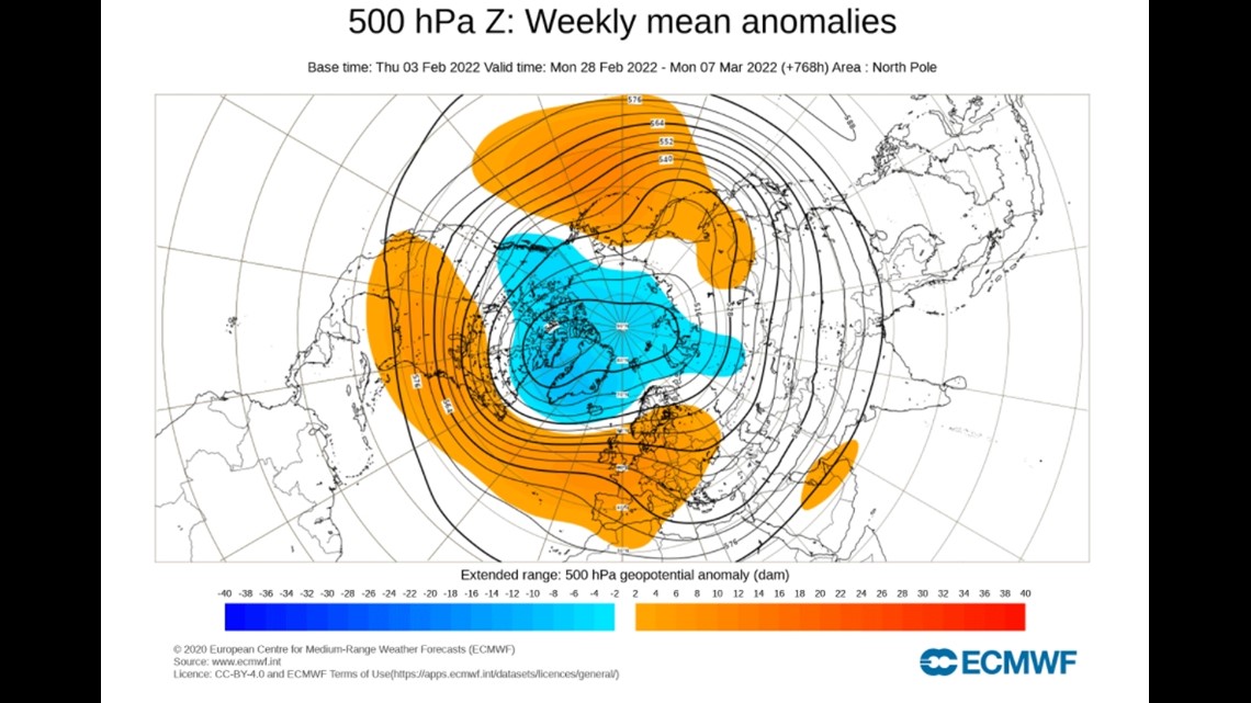

For the start of March, there is a low-pressure system over northwestern U.S., showing that they will experience colder temperatures. The ECMWF said that the cold air will be over eastern and central U.S.
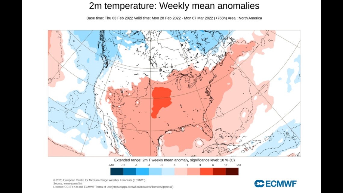
The Quad Cities is located in light red color of the temperature map and on the high-pressure map, so we should experience seasonable temperatures to slightly warmer than normal seasonal temperatures.

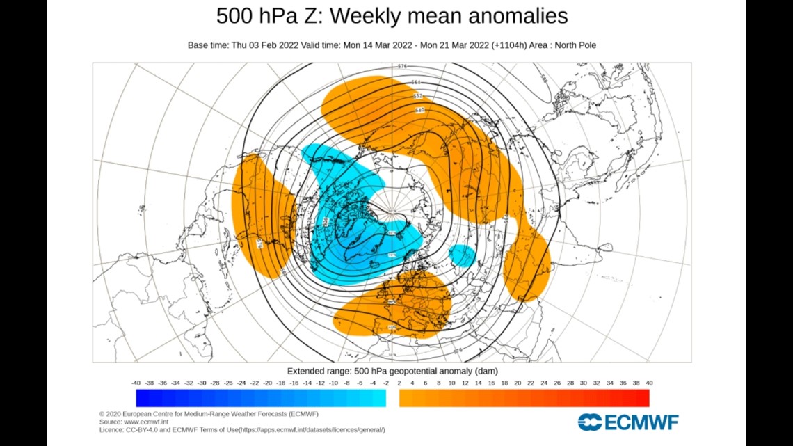

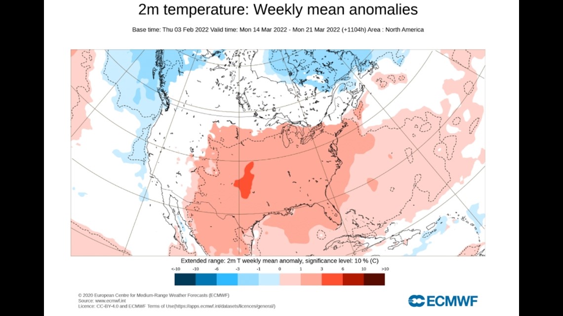
The end of March sees the low pressure air move northward into Canada, with some in the northwestern tip of the U.S. leaving high pressure air for the rest of the country. The majority of the U.S will then see warmer temperatures.
► Download the WQAD News 8 App
► Subscribe to our daily newsletter
► Subscribe to our YouTube channel